
- 1. API with NestJS #1. Controllers, routing and the module structure
- 2. API with NestJS #2. Setting up a PostgreSQL database with TypeORM
- 3. API with NestJS #3. Authenticating users with bcrypt, Passport, JWT, and cookies
- 4. API with NestJS #4. Error handling and data validation
- 5. API with NestJS #5. Serializing the response with interceptors
- 6. API with NestJS #6. Looking into dependency injection and modules
- 7. API with NestJS #7. Creating relationships with Postgres and TypeORM
- 8. API with NestJS #8. Writing unit tests
- 9. API with NestJS #9. Testing services and controllers with integration tests
- 10. API with NestJS #10. Uploading public files to Amazon S3
- 11. API with NestJS #11. Managing private files with Amazon S3
- 12. API with NestJS #12. Introduction to Elasticsearch
- 13. API with NestJS #13. Implementing refresh tokens using JWT
- 14. API with NestJS #14. Improving performance of our Postgres database with indexes
- 15. API with NestJS #15. Defining transactions with PostgreSQL and TypeORM
- 16. API with NestJS #16. Using the array data type with PostgreSQL and TypeORM
- 17. API with NestJS #17. Offset and keyset pagination with PostgreSQL and TypeORM
- 18. API with NestJS #18. Exploring the idea of microservices
- 19. API with NestJS #19. Using RabbitMQ to communicate with microservices
- 20. API with NestJS #20. Communicating with microservices using the gRPC framework
- 21. API with NestJS #21. An introduction to CQRS
- 22. API with NestJS #22. Storing JSON with PostgreSQL and TypeORM
- 23. API with NestJS #23. Implementing in-memory cache to increase the performance
- 24. API with NestJS #24. Cache with Redis. Running the app in a Node.js cluster
- 25. API with NestJS #25. Sending scheduled emails with cron and Nodemailer
- 26. API with NestJS #26. Real-time chat with WebSockets
- 27. API with NestJS #27. Introduction to GraphQL. Queries, mutations, and authentication
- 28. API with NestJS #28. Dealing in the N + 1 problem in GraphQL
- 29. API with NestJS #29. Real-time updates with GraphQL subscriptions
- 30. API with NestJS #30. Scalar types in GraphQL
- 31. API with NestJS #31. Two-factor authentication
- 32. API with NestJS #32. Introduction to Prisma with PostgreSQL
- 33. API with NestJS #33. Managing PostgreSQL relationships with Prisma
- 34. API with NestJS #34. Handling CPU-intensive tasks with queues
- 35. API with NestJS #35. Using server-side sessions instead of JSON Web Tokens
- 36. API with NestJS #36. Introduction to Stripe with React
- 37. API with NestJS #37. Using Stripe to save credit cards for future use
- 38. API with NestJS #38. Setting up recurring payments via subscriptions with Stripe
- 39. API with NestJS #39. Reacting to Stripe events with webhooks
- 40. API with NestJS #40. Confirming the email address
- 41. API with NestJS #41. Verifying phone numbers and sending SMS messages with Twilio
- 42. API with NestJS #42. Authenticating users with Google
- 43. API with NestJS #43. Introduction to MongoDB
- 44. API with NestJS #44. Implementing relationships with MongoDB
- 45. API with NestJS #45. Virtual properties with MongoDB and Mongoose
- 46. API with NestJS #46. Managing transactions with MongoDB and Mongoose
- 47. API with NestJS #47. Implementing pagination with MongoDB and Mongoose
- 48. API with NestJS #48. Definining indexes with MongoDB and Mongoose
- 49. API with NestJS #49. Updating with PUT and PATCH with MongoDB and Mongoose
- 50. API with NestJS #50. Introduction to logging with the built-in logger and TypeORM
- 51. API with NestJS #51. Health checks with Terminus and Datadog
- 52. API with NestJS #52. Generating documentation with Compodoc and JSDoc
- 53. API with NestJS #53. Implementing soft deletes with PostgreSQL and TypeORM
- 54. API with NestJS #54. Storing files inside a PostgreSQL database
- 55. API with NestJS #55. Uploading files to the server
- 56. API with NestJS #56. Authorization with roles and claims
- 57. API with NestJS #57. Composing classes with the mixin pattern
- 58. API with NestJS #58. Using ETag to implement cache and save bandwidth
- 59. API with NestJS #59. Introduction to a monorepo with Lerna and Yarn workspaces
- 60. API with NestJS #60. The OpenAPI specification and Swagger
- 61. API with NestJS #61. Dealing with circular dependencies
- 62. API with NestJS #62. Introduction to MikroORM with PostgreSQL
- 63. API with NestJS #63. Relationships with PostgreSQL and MikroORM
- 64. API with NestJS #64. Transactions with PostgreSQL and MikroORM
- 65. API with NestJS #65. Implementing soft deletes using MikroORM and filters
- 66. API with NestJS #66. Improving PostgreSQL performance with indexes using MikroORM
- 67. API with NestJS #67. Migrating to TypeORM 0.3
- 68. API with NestJS #68. Interacting with the application through REPL
- 69. API with NestJS #69. Database migrations with TypeORM
- 70. API with NestJS #70. Defining dynamic modules
- 71. API with NestJS #71. Introduction to feature flags
- 72. API with NestJS #72. Working with PostgreSQL using raw SQL queries
- 73. API with NestJS #73. One-to-one relationships with raw SQL queries
- 74. API with NestJS #74. Designing many-to-one relationships using raw SQL queries
- 75. API with NestJS #75. Many-to-many relationships using raw SQL queries
- 76. API with NestJS #76. Working with transactions using raw SQL queries
- 77. API with NestJS #77. Offset and keyset pagination with raw SQL queries
- 78. API with NestJS #78. Generating statistics using aggregate functions in raw SQL
- 79. API with NestJS #79. Implementing searching with pattern matching and raw SQL
- 80. API with NestJS #80. Updating entities with PUT and PATCH using raw SQL queries
- 81. API with NestJS #81. Soft deletes with raw SQL queries
- 82. API with NestJS #82. Introduction to indexes with raw SQL queries
- 83. API with NestJS #83. Text search with tsvector and raw SQL
- 84. API with NestJS #84. Implementing filtering using subqueries with raw SQL
- 85. API with NestJS #85. Defining constraints with raw SQL
- 86. API with NestJS #86. Logging with the built-in logger when using raw SQL
- 87. API with NestJS #87. Writing unit tests in a project with raw SQL
- 88. API with NestJS #88. Testing a project with raw SQL using integration tests
- 89. API with NestJS #89. Replacing Express with Fastify
- 90. API with NestJS #90. Using various types of SQL joins
- 91. API with NestJS #91. Dockerizing a NestJS API with Docker Compose
- 92. API with NestJS #92. Increasing the developer experience with Docker Compose
- 93. API with NestJS #93. Deploying a NestJS app with Amazon ECS and RDS
- 94. API with NestJS #94. Deploying multiple instances on AWS with a load balancer
- 95. API with NestJS #95. CI/CD with Amazon ECS and GitHub Actions
- 96. API with NestJS #96. Running unit tests with CI/CD and GitHub Actions
- 97. API with NestJS #97. Introduction to managing logs with Amazon CloudWatch
- 98. API with NestJS #98. Health checks with Terminus and Amazon ECS
- 99. API with NestJS #99. Scaling the number of application instances with Amazon ECS
- 100. API with NestJS #100. The HTTPS protocol with Route 53 and AWS Certificate Manager
- 101. API with NestJS #101. Managing sensitive data using the AWS Secrets Manager
- 102. API with NestJS #102. Writing unit tests with Prisma
- 103. API with NestJS #103. Integration tests with Prisma
- 104. API with NestJS #104. Writing transactions with Prisma
- 105. API with NestJS #105. Implementing soft deletes with Prisma and middleware
- 106. API with NestJS #106. Improving performance through indexes with Prisma
- 107. API with NestJS #107. Offset and keyset pagination with Prisma
- 108. API with NestJS #108. Date and time with Prisma and PostgreSQL
- 109. API with NestJS #109. Arrays with PostgreSQL and Prisma
- 110. API with NestJS #110. Managing JSON data with PostgreSQL and Prisma
- 111. API with NestJS #111. Constraints with PostgreSQL and Prisma
- 112. API with NestJS #112. Serializing the response with Prisma
- 113. API with NestJS #113. Logging with Prisma
- 114. API with NestJS #114. Modifying data using PUT and PATCH methods with Prisma
- 115. API with NestJS #115. Database migrations with Prisma
- 116. API with NestJS #116. REST API versioning
- 117. API with NestJS #117. CORS – Cross-Origin Resource Sharing
- 118. API with NestJS #118. Uploading and streaming videos
- 119. API with NestJS #119. Type-safe SQL queries with Kysely and PostgreSQL
- 120. API with NestJS #120. One-to-one relationships with the Kysely query builder
- 121. API with NestJS #121. Many-to-one relationships with PostgreSQL and Kysely
- 122. API with NestJS #122. Many-to-many relationships with Kysely and PostgreSQL
- 123. API with NestJS #123. SQL transactions with Kysely
- 124. API with NestJS #124. Handling SQL constraints with Kysely
- 125. API with NestJS #125. Offset and keyset pagination with Kysely
- 126. API with NestJS #126. Improving the database performance with indexes and Kysely
- 127. API with NestJS #127. Arrays with PostgreSQL and Kysely
- 128. API with NestJS #128. Managing JSON data with PostgreSQL and Kysely
- 129. API with NestJS #129. Implementing soft deletes with SQL and Kysely
- 130. API with NestJS #130. Avoiding storing sensitive information in API logs
- 131. API with NestJS #131. Unit tests with PostgreSQL and Kysely
- 132. API with NestJS #132. Handling date and time in PostgreSQL with Kysely
- 133. API with NestJS #133. Introducing database normalization with PostgreSQL and Prisma
- 134. API with NestJS #134. Aggregating statistics with PostgreSQL and Prisma
- 135. API with NestJS #135. Referential actions and foreign keys in PostgreSQL with Prisma
- 136. API with NestJS #136. Raw SQL queries with Prisma and PostgreSQL range types
- 137. API with NestJS #137. Recursive relationships with Prisma and PostgreSQL
- 138. API with NestJS #138. Filtering records with Prisma
- 139. API with NestJS #139. Using UUID as primary keys with Prisma and PostgreSQL
- 140. API with NestJS #140. Using multiple PostgreSQL schemas with Prisma
- 141. API with NestJS #141. Getting distinct records with Prisma and PostgreSQL
- 142. API with NestJS #142. A video chat with WebRTC and React
- 143. API with NestJS #143. Optimizing queries with views using PostgreSQL and Kysely
- 144. API with NestJS #144. Creating CLI applications with the Nest Commander
- 145. API with NestJS #145. Securing applications with Helmet
- 146. API with NestJS #146. Polymorphic associations with PostgreSQL and Prisma
- 147. API with NestJS #147. The data types to store money with PostgreSQL and Prisma
- 148. API with NestJS #148. Understanding the injection scopes
- 149. API with NestJS #149. Introduction to the Drizzle ORM with PostgreSQL
- 150. API with NestJS #150. One-to-one relationships with the Drizzle ORM
- 151. API with NestJS #151. Implementing many-to-one relationships with Drizzle ORM
- 152. API with NestJS #152. SQL constraints with the Drizzle ORM
- 153. API with NestJS #153. SQL transactions with the Drizzle ORM
- 154. API with NestJS #154. Many-to-many relationships with Drizzle ORM and PostgreSQL
- 155. API with NestJS #155. Offset and keyset pagination with the Drizzle ORM
- 156. API with NestJS #156. Arrays with PostgreSQL and the Drizzle ORM
- 157. API with NestJS #157. Handling JSON data with PostgreSQL and the Drizzle ORM
- 158. API with NestJS #158. Soft deletes with the Drizzle ORM
- 159. API with NestJS #159. Date and time with PostgreSQL and the Drizzle ORM
- 160. API with NestJS #160. Using views with the Drizzle ORM and PostgreSQL
- 161. API with NestJS #161. Generated columns with the Drizzle ORM and PostgreSQL
- 162. API with NestJS #162. Identity columns with the Drizzle ORM and PostgreSQL
- 163. API with NestJS #163. Full-text search with the Drizzle ORM and PostgreSQL
- 164. API with NestJS #164. Improving the performance with indexes using Drizzle ORM
- 165. API with NestJS #165. Time intervals with the Drizzle ORM and PostgreSQL
- 166. API with NestJS #166. Logging with the Drizzle ORM
- 167. API with NestJS #167. Unit tests with the Drizzle ORM
- 168. API with NestJS #168. Integration tests with the Drizzle ORM
- 169. API with NestJS #169. Unique IDs with UUIDs using Drizzle ORM and PostgreSQL
- 170. API with NestJS #170. Polymorphic associations with PostgreSQL and Drizzle ORM
- 171. API with NestJS #171. Recursive relationships with Drizzle ORM and PostgreSQL
- 172. API with NestJS #172. Database normalization with Drizzle ORM and PostgreSQL
- 173. API with NestJS #173. Storing money with Drizzle ORM and PostgreSQL
- 174. API with NestJS #174. Multiple PostgreSQL schemas with Drizzle ORM
- 175. API with NestJS #175. PUT and PATCH requests with PostgreSQL and Drizzle ORM
- 176. API with NestJS #176. Database migrations with the Drizzle ORM
- 177. API with NestJS #177. Response serialization with the Drizzle ORM
- 178. API with NestJS #178. Storing files inside of a PostgreSQL database with Drizzle
- 179. API with NestJS #179. Pattern matching search with Drizzle ORM and PostgreSQL
- 180. API with NestJS #180. Organizing Drizzle ORM schema with PostgreSQL
- 181. API with NestJS #181. Prepared statements in PostgreSQL with Drizzle ORM
- 182. API with NestJS #182. Storing coordinates in PostgreSQL with Drizzle ORM
- 183. API with NestJS #183. Distance and radius in PostgreSQL with Drizzle ORM
- 184. API with NestJS #184. Storing PostGIS Polygons in PostgreSQL with Drizzle ORM
- 185. API with NestJS #185. Operations with PostGIS Polygons in PostgreSQL and Drizzle
- 186. API with NestJS #186. What’s new in Express 5?
- 187. API with NestJS #187. Rate limiting using Throttler
PostgreSQL provides many options for working with geographical data, especially with the PostGIS extension. In this article, we’ll explore how to calculate the distance between two coordinates and how to identify locations within a specific radius.
If you want to check out the basics of storing coordinates in PostgreSQL with the Drizzle ORM, check out API with NestJS #182. Storing coordinates in PostgreSQL with Drizzle ORM
Spatial Reference System Identifier
We will use a straightforward database schema that contains a table with locations.
database-schema.ts
|
1 2 3 4 5 6 7 8 9 10 11 12 13 14 15 |
import { serial, text, pgTable, geometry } from 'drizzle-orm/pg-core'; export const locations = pgTable('locations', { id: serial().primaryKey(), name: text().notNull(), coordinates: geometry('coordinates', { type: 'point', mode: 'xy', srid: 4326, }).notNull(), }); export const databaseSchema = { locations, }; |
Above, we specify the Spatial Reference System Identifier (SRID). This number tells PostGIS how to interpret the coordinates. It specifies one of several coordinate systems used to represent the data.
- In SRID 4326, the coordinates are defined in latitude and longitude.
- In SRID 3857, the coordinates are specified in meters on a flat map.
If two sets of coordinates use different SRIDs, they are based on different systems and won’t line up correctly. For example, comparing latitude/longitude directly to flat map coordinates will give incorrect results.
The default SRID in PostGIS is 0, which means the data has no defined coordinate system. It’s good practice to define the SRID for our data explicitly.
Let’s create the SQL migration to add our table to the database.
If you want to know more about migrations with the Drizzle ORM, check out API with NestJS #176. Database migrations with the Drizzle ORM
|
1 |
npx drizzle-kit generate --name add-locations-table |
database-schema.ts
|
1 2 3 4 5 |
CREATE TABLE IF NOT EXISTS "locations" ( "id" serial PRIMARY KEY NOT NULL, "name" text NOT NULL, "coordinates" geometry(point) NOT NULL ); |
Unfortunately, right now, Drizzle ORM has a bug that causes it to ignore the provided SRID. To deal with that, we have to adjust our migration manually. Let’s also add a line ensuring the PostGIS extension is set up.
database-schema.ts
|
1 2 3 4 5 6 7 |
CREATE EXTENSION IF NOT EXISTS postgis; CREATE TABLE IF NOT EXISTS "locations" ( "id" serial PRIMARY KEY NOT NULL, "name" text NOT NULL, "coordinates" geometry(point, 4326) NOT NULL ); |
Calculating the distance between two points
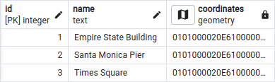
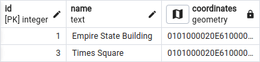
Let’s insert a few locations into our database:
- Empire State Building in New York
- Santa Monica Pier in the Los Angeles County
- Times Square in New York
Let’s calculate the distance between the Empire State Building and the Santa Monica Pier. To do that, we can use the ST_DistanceSphere function built into PostgreSQL.
|
1 2 3 4 |
SELECT ST_DistanceSphere( (SELECT coordinates FROM locations WHERE id = 1), (SELECT coordinates FROM locations WHERE id = 2) ) as distance; |
The result is roughly 3960 kilometers (about 2460 miles). What’s crucial is that the ST_DistanceSphere function takes into account that Earth is a sphere. To use it with the Drizzle ORM, we need to provide the raw SQL.
locations.service.ts
|
1 2 3 4 5 6 7 8 9 10 11 12 13 14 15 16 17 18 19 20 21 22 23 24 25 26 27 28 29 30 31 32 33 |
import { Injectable, NotFoundException } from '@nestjs/common'; import { DrizzleService } from '../database/drizzle.service'; import { databaseSchema } from '../database/database-schema'; import { sql } from 'drizzle-orm'; @Injectable() export class LocationsService { constructor(private readonly drizzleService: DrizzleService) {} async getDistanceBetweenLocations( firstLocationId: number, secondLocationId: number, ) { const queryResult = await this.drizzleService.db.execute( sql` SELECT ST_DistanceSphere( (SELECT coordinates FROM ${databaseSchema.locations} WHERE id = ${firstLocationId}), (SELECT coordinates FROM ${databaseSchema.locations} WHERE id = ${secondLocationId}) ) AS distance; `, ); const distance = queryResult.rows.pop()?.distance; if (distance === null) { throw new NotFoundException(); } return distance; } // ... } |
The Earth is not a perfect sphere
What’s interesting is that ST_DistanceSphere assumes that Earth is a perfect sphere. However, this is not the case. To be more precise, we can use the ST_DistanceSpheroid function, which accounts for Earth’s ellipsoidal shape.
|
1 2 3 4 5 |
SELECT ST_DistanceSpheroid( (SELECT coordinates FROM locations WHERE id = 1), (SELECT coordinates FROM locations WHERE id = 2), 'SPHEROID["WGS 84",6378137,298.257223563]' ) AS distance; |
By providing SPHEROID["WGS 84",6378137,298.257223563] we specify the Earth’s shape, using the WGS84 model.
The above query results in roughly 3969 kilometers (about 2466 miles). It is 9 kilometers more than the ST_DistanceSphere function returned. If we want to calculate big distances, taking the Earth’s shape into account can give us more precise results.
Getting locations in a certain radius
Another very useful feature is finding locations in a certain radius. To do that, we need to use the ST_DWithin function built into PostGIS.
So far, we’ve been using the geometry data type built into PostGIS that treats Earth as a flat 2D plane. However, when combined with functions such as ST_DistanceSpheroid, which we used above, it can calculate distances on a spherical Earth.
Alternatively, PostGIS implements the geography data type, which automatically accounts for the Earth’s ellipsoidal shape. Unfortunately, the Drizzle ORM does not currently support this type of data. To use the ST_DWithin function, we need to convert our data to geography on the fly.
|
1 2 3 4 5 6 |
SELECT * FROM locations WHERE ST_DWithin( coordinates::geography, (SELECT coordinates::geography FROM locations WHERE id = 1), 5000 -- Radius in meters ); |
Above, we find all the locations in a 5-kilometer radius of the Empire State Building in New York.
We can exclude the Empire State Building from our results to receive more meaningful results.
|
1 2 3 4 5 6 7 |
SELECT * FROM locations WHERE id != 1 AND ST_DWithin( coordinates::geography, (SELECT coordinates::geography FROM locations WHERE id = 1), 5000 -- Radius in meters ); |
To use ST_DWithin with the Drizzle ORM, we need to incorporate raw SQL into our code. Drizzle ORM handles most of the query, while the raw SQL is only used partly in the WHERE clause.
locations.service.ts
|
1 2 3 4 5 6 7 8 9 10 11 12 13 14 15 16 17 18 19 20 21 22 23 24 25 26 27 |
import { Injectable } from '@nestjs/common'; import { DrizzleService } from '../database/drizzle.service'; import { databaseSchema } from '../database/database-schema'; import { ne, sql, and } from 'drizzle-orm'; @Injectable() export class LocationsService { constructor(private readonly drizzleService: DrizzleService) {} getLocationsInRadius(locationId: number, radiusInMeters: number) { return this.drizzleService.db .select() .from(databaseSchema.locations) .where( and( ne(databaseSchema.locations.id, locationId), sql`ST_DWithin( ${databaseSchema.locations.coordinates}::geography, (SELECT ${databaseSchema.locations.coordinates}::geography FROM ${databaseSchema.locations} WHERE id = ${locationId}), ${radiusInMeters} )`, ), ); } // ... } |
Summary
In this article, we learned how to use PostGIS with the Drizzle ORM to calculate the distance between two coordinates and find all locations within a certain radius.
PostgreSQL offers many functionalities for various coordinate calculations thanks to the PostGIS extension. While the integration with Drizzle ORM isn’t perfect, we can work around most problems to get the job done. Assuming that the Drizzle team continues to improve the ORM, it has the potential to become a solid choice for handling spatial data.
